{domain:"www.qualitydigest.com",server:"169.47.211.87"} Skip to main content

User account menu
Main navigation
  • Topics
    • Customer Care
    • FDA Compliance
    • Healthcare
    • Innovation
    • Lean
    • Management
    • Metrology
    • Operations
    • Risk Management
    • Six Sigma
    • Standards
    • Statistics
    • Supply Chain
    • Sustainability
    • Training
  • Videos/Webinars
    • All videos
    • Product Demos
    • Webinars
  • Advertise
    • Advertise
    • Submit B2B Press Release
    • Write for us
  • Metrology Hub
  • Training
  • Subscribe
  • Log in
Mobile Menu
  • Home
  • Topics
    • 3D Metrology-CMSC
    • Customer Care
    • FDA Compliance
    • Healthcare
    • Innovation
    • Lean
    • Management
    • Metrology
    • Operations
    • Risk Management
    • Six Sigma
    • Standards
    • Statistics
    • Supply Chain
    • Sustainability
    • Training
  • Login / Subscribe
  • More...
    • All Features
    • All News
    • All Videos
    • Contact
    • Training

Automated Laser Scanner Monitors Tunnel Under Aging Infrastructure

Near-real-time geotechnical monitoring supports construction of Seattle’s light rail system.

Leica Geosystems
Tue, 06/22/2010 - 16:26
  • Comment
  • RSS

Social Sharing block

  • Print
Body

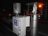
(Leica Geosystems, Norcross, GA) -- Geo-Instruments has implemented one of the industry’s first automated laser scanning systems using Leica Geosystems technology for near-real-time geotechnical monitoring. The system is used to support construction of the Puget Sound Regional Transit Authority’s (Sound Transit) University Link (U-Link) light rail extension in Seattle.

The U-Link light rail extension will connect the three largest urban centers in Washington state. Beginning in 2011, the tunnel-boring machines will excavate a 3.5-mile, twin-bored tunnel from downtown Seattle to the University of Washington. Key to the project’s success is the ability to tunnel under Interstate 5, a major artery near downtown Seattle, without affecting the aging infrastructure, deep foundations, and existing utility lines.

ADVERTISEMENT

Prior to excavation, Geo-Instruments installed a laser scanner-based fixed monitoring system to track fractional movements of the walls and highway surrounding the intersection during pit excavations and tunnel-boring machine passage.

 …

Want to continue?
Log in or create a FREE account.
Enter your username or email address
Enter the password that accompanies your username.
By logging in you agree to receive communication from Quality Digest. Privacy Policy.
Create a FREE account
Forgot My Password

Add new comment

Image CAPTCHA
Enter the characters shown in the image.
Please login to comment.
      

© 2025 Quality Digest. Copyright on content held by Quality Digest or by individual authors. Contact Quality Digest for reprint information.
“Quality Digest" is a trademark owned by Quality Circle Institute Inc.

footer
  • Home
  • Print QD: 1995-2008
  • Print QD: 2008-2009
  • Videos
  • Privacy Policy
  • Write for us
footer second menu
  • Subscribe to Quality Digest
  • About Us
  • Contact Us