{domain:"www.qualitydigest.com",server:"169.47.211.87"} Skip to main content

User account menu
Main navigation
  • Topics
    • Customer Care
    • FDA Compliance
    • Healthcare
    • Innovation
    • Lean
    • Management
    • Metrology
    • Operations
    • Risk Management
    • Six Sigma
    • Standards
    • Statistics
    • Supply Chain
    • Sustainability
    • Training
  • Videos/Webinars
    • All videos
    • Product Demos
    • Webinars
  • Advertise
    • Advertise
    • Submit B2B Press Release
    • Write for us
  • Metrology Hub
  • Training
  • Subscribe
  • Log in
Mobile Menu
  • Home
  • Topics
    • 3D Metrology-CMSC
    • Customer Care
    • FDA Compliance
    • Healthcare
    • Innovation
    • Lean
    • Management
    • Metrology
    • Operations
    • Risk Management
    • Six Sigma
    • Standards
    • Statistics
    • Supply Chain
    • Sustainability
    • Training
  • Login / Subscribe
  • More...
    • All Features
    • All News
    • All Videos
    • Contact
    • Training

What Happened to That Bridge?

Quality Digest
Wed, 08/08/2007 - 22:00
  • Comment
  • RSS

Social Sharing block

  • Print
Body

(Leica Geosystems: San Ramon, California) -- Leica Geosystems assisted the California Highway Patrol’s multidisciplinary accident investigation team (MAIT) at the recent collapse of a major San Francisco-area overpass. The CHP brought a Leica ScanStation 3-D laser scanner to map the scene, and Leica Geosystems dispatched an application engineer to help collect and process the accident-scene data.

The accident occurred in the early morning hours on April 29, when a tanker truck carrying more than 8,600 gallons of gasoline crashed on the “MacArthur maze,” an approach to the San Francisco-Oakland Bay Bridge, igniting a 3,000°F fire and causing the I-580 overpass to collapse onto another interstate highway below.

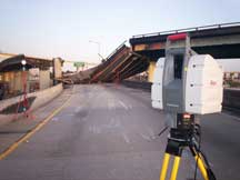
The CHP was on the scene within minutes of the incident. Once it was safe, MAIT members set up the Leica ScanStation and collected high-accuracy data from the ground to the top of the destroyed overpass. Leica Geosystems’ application engineer assisted the CHP in documenting the scene.

Recording forensic evidence to map the complex 3-D-accident scene was further complicated by contractors demolishing the overpass as MAIT members were scanning the scene.

 …

Want to continue?
Log in or create a FREE account.
Enter your username or email address
Enter the password that accompanies your username.
By logging in you agree to receive communication from Quality Digest. Privacy Policy.
Create a FREE account
Forgot My Password

Add new comment

Image CAPTCHA
Enter the characters shown in the image.
Please login to comment.
      

© 2025 Quality Digest. Copyright on content held by Quality Digest or by individual authors. Contact Quality Digest for reprint information.
“Quality Digest" is a trademark owned by Quality Circle Institute Inc.

footer
  • Home
  • Print QD: 1995-2008
  • Print QD: 2008-2009
  • Videos
  • Privacy Policy
  • Write for us
footer second menu
  • Subscribe to Quality Digest
  • About Us
  • Contact Us