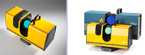
(Basis: Redmond, WA) -- Basis Software has introduced the Surphaser Model 10 laser scanner, the first in a new product line of compact lightweight scanners. The new model was presented April 2–5, 2015, at the SPAR 3D Expo and Conference in Woodlands, Texas.
ADVERTISEMENT |
The Surphaser Model 10 represents an entirely new branch on the Surphaser model tree. Model 10 continues to provide the data quality and submillimeter accuracy that has long separated Surphaser scanners from the competition. In addition, model 10 introduces an integrated camera, internal battery compartment, and onboard control. Weighing in at 5 kg (11 lb) that makes model 10 the smallest and lightest Surphaser to date.
Surphaser is introducing Model 10 as an addition to its product line to provide solutions for a wide range of applications, from dimensional control to aerospace to asset management and BIM. Model 10 uses Class 1 laser to capture a 360° x 270° field of view with a 3D error of <0.7 mm (at 15 m) and range noise of <0.12mm (at 15m/90% albedo). The two integrated 5MP cameras provide automatic color-texture mapping with the included software.
In addition, Basis Software and GeoSLAM Ltd. have launched SurphSLAM, a trolley-based mobile mapping system that combines the new Surphaser 10 laser scanner and GeoSLAM’s new RealTime SLAM registration software. Driven by user demand for a high-precision, real-time mobile scanning system SurphSLAM can be used for extremely accurate high-resolution 3D mobile mapping without the need for GPS. This unique integration of technologies also allows for the resulting point cloud to be registered and displayed in real time, facilitating performance and speed of survey.
“Surphaser scanners are well known for producing high-accuracy data sets with ultra-low noise levels,” says Peter Petrov, president of Basis Software. “This continues in the new Surphaser model 10, the combination of scanner’s speed, low range noise, submillimeter accuracy, and reduced size making it a perfect candidate for a versatile mobile mapping system such as SurphSLAM. When joined with the custom-designed lightweight and collapsible trolley and GeoSLAM’s industry-leading SLAM software, SurphSLAM fulfills a new market niche.”
Mark Reid, COO at GeoSLAM, concurs. “SurphSLAM is an exciting new development and represents two firsts for GeoSLAM,” he says. “It’s the first introduction of our new GeoSLAM RealTime software, which builds on the success of our existing SLAM solutions and utilizes our award winning 3D SLAM algorithm, and it’s also the first time we have opened up our software to be used by a third-party hardware vendor. The results from SurphSLAM are phenomenal, and we look forward to continuing to lead the way in SLAM-based mobile mapping systems.”
SurphSLAM is exclusively available from Surphaser and Surphaser-authorised distributors. To find out more, download the brochure and spec sheet for hte Surphaser Model 10 scanner, or download the brochure and spec sheet for the SurphSLAM mobile mapping system.
Add new comment