{domain:"www.qualitydigest.com",server:"169.47.211.87"} Skip to main content

User account menu
Main navigation
  • Topics
    • Customer Care
    • FDA Compliance
    • Healthcare
    • Innovation
    • Lean
    • Management
    • Metrology
    • Operations
    • Risk Management
    • Six Sigma
    • Standards
    • Statistics
    • Supply Chain
    • Sustainability
    • Training
  • Videos/Webinars
    • All videos
    • Product Demos
    • Webinars
  • Advertise
    • Advertise
    • Submit B2B Press Release
    • Write for us
  • Metrology Hub
  • Training
  • Subscribe
  • Log in
Mobile Menu
  • Home
  • Topics
    • 3D Metrology-CMSC
    • Customer Care
    • FDA Compliance
    • Healthcare
    • Innovation
    • Lean
    • Management
    • Metrology
    • Operations
    • Risk Management
    • Six Sigma
    • Standards
    • Statistics
    • Supply Chain
    • Sustainability
    • Training
  • Login / Subscribe
  • More...
    • All Features
    • All News
    • All Videos
    • Contact
    • Training

Photogrammetry and Sonar Update Maps Help Keep Shipping Safe

Survey by autonomous watercraft is part of a three-year research project

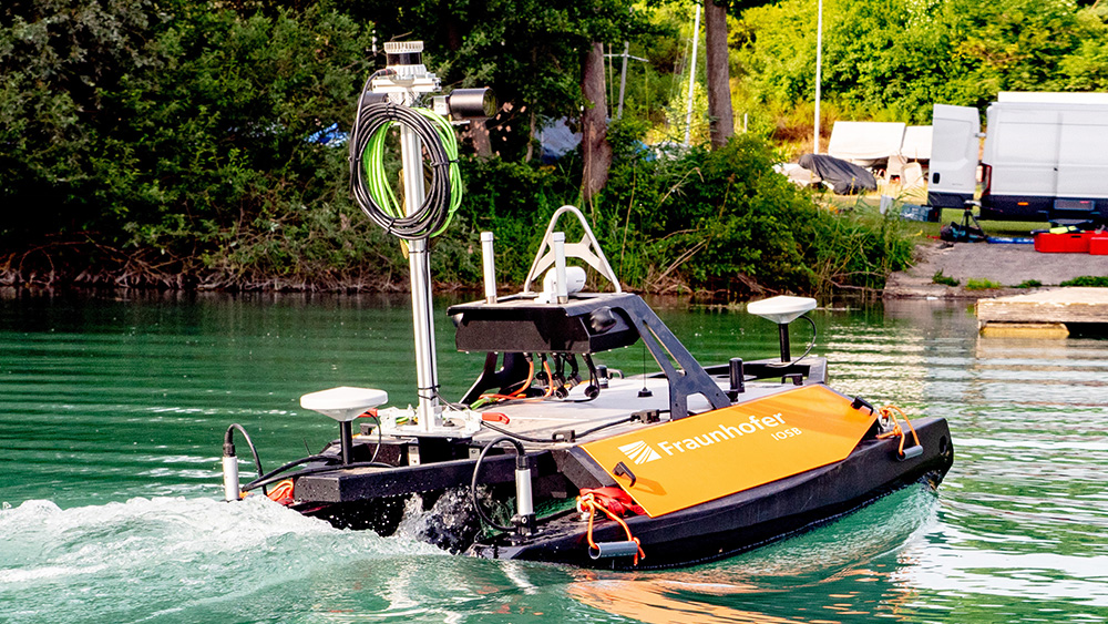
TAPS, the semi-automatic sounding system for rivers and lakes, measures bodies of water independently.

Sabine Terrasi
Mon, 08/26/2024 - 12:02
  • Comment
  • RSS

Social Sharing block

  • Print
Body

Up-to-date and accurate maps of the waterways are a prerequisite for safe and efficient shipping in Germany. Authorities such as the Federal Maritime and Hydrographic Agency, but also private harbor operators, are obliged to provide these maps in an up-to-date form at all times. Primarily, the reason is to prevent accidents caused by incorrect or outdated nautical charts. This includes the classification of federal waterways; their length in kilometers; existing locks, lifts, and barrages; and other surrounding waters, places, and borders.

ADVERTISEMENT

Currently, mapping is carried out by conventional ships with trained personnel, which is time-consuming and expensive. This can result in long intervals between measurements at a particular location.

 …

Want to continue?
Log in or create a FREE account.
Enter your username or email address
Enter the password that accompanies your username.
By logging in you agree to receive communication from Quality Digest. Privacy Policy.
Create a FREE account
Forgot My Password

Add new comment

Image CAPTCHA
Enter the characters shown in the image.
Please login to comment.
      

© 2025 Quality Digest. Copyright on content held by Quality Digest or by individual authors. Contact Quality Digest for reprint information.
“Quality Digest" is a trademark owned by Quality Circle Institute Inc.

footer
  • Home
  • Print QD: 1995-2008
  • Print QD: 2008-2009
  • Videos
  • Privacy Policy
  • Write for us
footer second menu
  • Subscribe to Quality Digest
  • About Us
  • Contact Us