 Back
to the Future With Laser Radar Back
to the Future With Laser Radar
Leica LR200 Laser Radar Systems
During the Cretaceous Period--some
65 to 85 million years ago--the tyrannosaurus rex roamed
across North America and Mongolia with relative impunity.
Despite its comically useless and puny arms, the dinosaur
enjoyed a life of carnivorous bliss, feasting on contemporaries
like the triceratops and the iguanodon and enjoying its
status as predatory “lizard in chief.” Early
man arrived on the scene about 2 million years ago, after
a mass extinction wiped out the dinosaurs. Preoccupied with
activities like basic survival and wheel invention, early
men and women gave little thought to the planet’s
former reptilian inhabitants. It wasn’t until 1902
that T-rex reappeared on the radar screen, surfacing in
Montana. A century later--at the hands of two Leica LR200
Laser Radar systems--the world’s most famous dinosaur
had finally been captured.
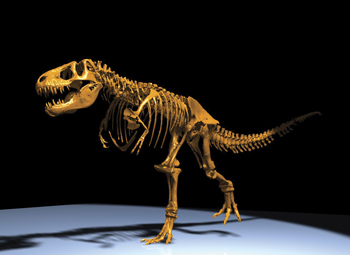
Reduced to the fossilized remnants of its skeleton, a
massive T-rex stands in Dinosaur Hall at the Carnegie Museum
of Natural History in Pittsburgh. Metrology experts from
MAGLEV Inc., Leica Geosystems and MetricVision Inc. have
swarmed the dinosaur in recent weeks to scan its surfaces,
poring over each fossa and foramen to create the basis for
what is intended to be the most accurate and complete digital
model of a tyrannosaurus rex to date.
The team’s principal tool was a pair of networked
LR200 coherent laser radars. Perched upon 6-foot towers
and navigated around the perimeter of the skeleton, the
laser radars collected point clouds, 3-D data sets that
provide a virtual picture of the creature. The LR200 was
an apposite choice; accurate up to 20 µm, it measures
large objects with scan rates up to 1,000 points per second
at volumes up to 48 m. Furthermore, the Leica LR200 is the
first noncontact measurement device to combine radar, laser
and 3-D software technologies within the same product.
Although primarily used in industrial settings, the paleontological
application of the LR200 is a key component in an effort
to more solidly establish the appearance and nature of tyrannosaurus
rex. Experts now believe the tyrannosaurus species carried
its tail high in the air; thus Carnegie wishes to not only
remount T-rex in this position but also to pose the dinosaur
facing a second tyrannosaurus rex. With an exact computer
digital replica, the museum will be able to easily model
the 3-D skeleton in different configurations, choose the
most appealing positions and then design the required support
system. The high-precision data gathered by the LR200 can
also be used for scientific analysis of T-rex’s fossilized
bones.
To create the digital replica, MAGLEV will use the point
clouds gathered by the two LR200s to measure and build a
3-D computer solid model--an exact digital prototype of
the 17 ft. tall dinosaur. A 3-D printing process that uses
metals, ceramics or metal ceramic composites for rapid part
production will then be used to create a physical prototype.
The Extrude Hone Corp. will utilize the solid model to create
a physical prototype with its exclusive 3-D printing process,
which uses metals, ceramics or metal ceramic composites
for rapid part production.
“Using a direct-measurement instrument, we are capturing
high-precision T-rex surface data in contrast to less accurate
artistic methods,” says Steve Hand, an expert metrologist
and project manager at MAGLEV Inc. “The laser radar
has enabled us to acquire accuracy up to 250 µm. Using
the resultant 3-D computer model, Carnegie paleontologists
will be able to take T-rex apart in sections, even vertebrae
by vertebrae, to reposition the dinosaur.”
Scientists can’t take the capability to dissemble
and reposition fossilized skeletons with such definitive
accuracy for granted. Before the advent of even rudimentary
computer modeling transformed the process, the painstaking
work of ensuring correct articulation and positioning of
every bone could take hundreds of hours. “But the
benefits of the scan do not stop here,” continues
Hand. “The precise model will serve as the foundation
for scientific analysis, comparisons to other fossils and
more. Based on the same level of precision, we will use
the laser radar technology to build highly accurate guideway
beams for high-speed magnetically levitating trains.”
Although metrology equipment isn’t often associated
with such exciting endeavors, the LR200 has broken the mold
by bringing laser radar technology to the world of 65 million
year-old fossils and levitating trains. Lasers, radar, dinosaurs
and flying mass-transit--it’s not a 1970s Godzilla
film; it’s just contemporary metrology at work.
Leica LR200 Laser Radar Systems
- Large-scale mobile scanning on any surface
- Scan rates up to 1,000 points per second at volumes
up to 48 m.
www.leica-geosystems.com/metrology
|