Social Sharing block
Moles are invading Seattle. Not the small, furry mammals often reviled for destroying lawns, but the specialized boring machines used to excavate tunnels in urban environments. As part of its long-range capital investment plan, Central Puget Sound Regional Transit Authority, known simply as “Sound Transit,” recently initiated the University Link (U-Link) light rail extension that will serve the three largest urban centers in the state—downtown Seattle, Capitol Hill, and the University District.
|
ADVERTISEMENT |
Beginning in 2011, the tunnel-boring machines will excavate a 3.5-mile, twin-bored tunnel from downtown Seattle to the University of Washington during the initial stages of the U-Link construction. Key to the success of this initiative is the ability to tunnel under Interstate 5, a major artery near downtown Seattle, without affecting the highway’s aging infrastructure, deep foundations, and existing utility lines. Built during the 1960s, this section of I-5 is supported by 400-foot-long retaining walls that range from 30 to 40 feet tall. As part of the I-5 Undercrossing project (also known as the U215 project), design engineers called on the Washington office of Narragansett, Rhode Island-based Geo-Instruments to monitor the walls and highway throughout pit excavations and tunnel-boring machine passage.
 |
|
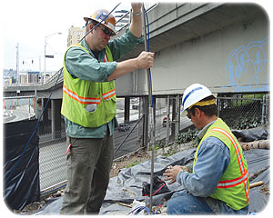
Figure 1: Geo-Instruments crews install solar-powered, in-place inclinometer sensors as a backup to the laser scanner-based geotechnical monitoring system.
|
The design team wanted measurements obtained through traditional geotechnical instruments such as tiltmeters, inclinometers, and linked beam sensors. They also requested the use of laser scanners integrated into a fixed monitoring system. Geo-Instruments agreed and further provided custom purpose-specific programming—subsequently debuting the world’s first known automated pulsed laser scanner application for near-real-time geotechnical monitoring and the first wireless sensor network in North America.
Minimizing movement
The I-5/U215 undercrossing project involves digging 50-foot-deep access shafts under both sides of I-5 for the tunnel alignment. These shafts will help in modifying the existing foundation elements of the retaining structure to make the tunnel-boring machine passage more predictable. Beginning in March 2009, Sound Transit gave Geo-Instruments four weeks to install the necessary instrumentation along the busy I-5 corridor.
The first step was to install the tiltmeters, linked beam sensor arrays, and angled laser scan targets (see figure 1). Geo-Instruments sent two three-person crews to position the targets at two-foot intervals along the retaining wall at 10 predefined scan-line locations.
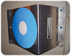
Fabricated at the Geo-Instruments factory, the laser scan targets are made of an aluminum base with circular laser-scan reflective areas and a horizontal angle offset to maintain perpendicularity to the laser scan locations (see figure 2). Approximately 250 scan targets were installed at the site (see figure 3). The targets provide the system with a precise array of positions to measure vertical displacement and settlement of the walls. They also provide reference points to adjust the position of the scanners in case the scanners are moved (see figure 4).
 |
|
Figure 2: The laser scan targets were made of an aluminum base with circular laser scan reflective areas and a special horizontal angle offset to maintain perpendicularity to the laser scan locations.
|
The Geo-Instruments team then positioned two Leica ScanStation 2 scanners on both sides of I-5 to scan the horizontal arrays and surrounding infrastructure (see figure 6). The scanners had visibility to the northbound and southbound highway and were within sight of the reversible express lane. They were fitted with a lightweight carbon-fiber cover to protect the units from weather and vandalism. The scanners’ on-site computer was fitted with a locked protective cover, wireless evolution data optimized (EVDO) modems and a wired digital subscriber line (DSL) as redundant communications paths.
The scanners are controlled by a custom computer program jointly developed by Geo-Instruments and Landmarker Geospatial that directs them to collect scan targets, process least-squares corrections, and scan line points for upload to the real-time project-based website. Twice per day, the scanners automatically scan infrastructure elements that are potentially affected by the construction under and adjacent to I-5 to within two millimeters along scan lines of one inch by one inch. Each 360° scan covers a four feet-by-four-feet swath at a distance of 380 feet. The total data load is greater than one gigabyte per day.
The on-site PC calculates scan target positions and then uploads the data as vertical profiles to the website. Scan data are housed off site on Geo-Instruments’ FTP servers for future use by the client.
 |
|
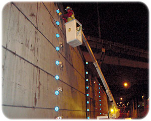
Figure 3: Positioning the laser scan targets at predefined locations along I-5
|
The laser scanners provide the flexibility to collect data and allow the team to analyze unexpected areas as needed. One of the benefits is the ability to pick up measurements at locations where the specifications did not call for sensors or where sensors are not practical.
As a backup, Geo-Instruments relies on two automated, motorized total stations for 3-D discrete point monitoring, as well as for measuring settlement and 3-D coordinates on the walls. There are also four vertical and eight horizontal inclinometer arrays in place to monitor wall settlement. Six data-logging systems connected to redundant wireless telemetry—along with the local DSL with wireless fidelity (Wi-Fi) network and redundant EVDO wireless IP connections to critical assets—accommodate the data load for the project.
A WiSe approach
WiSe is a wireless sensors network system that eliminates the need to run cables on the retaining wall where construction crews will install massive tiebacks and whalers (see figure 5). An efficient and easy measurement system, WiSe is typically used to measure multiple sensors. However, on the U215 project, the system is being used in tiltmeter mode to measure structural rotation at one point in the wall.
The wireless sensors broadcast data from unit to unit and across 400 feet of highway. Because there is an ancient landslide near the caissons that support the I-5 wall, Geo-Instruments also installed in-place inclinometer (IPI) sensors in the ground to measure the lateral displacement of soil and rock. The sensors are powered by solar energy. The IPIs are a first-line measurement to detect landslides and excavation support displacements.
 |
|
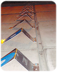
Figure 4: Close up of laser-scan target array
|
A secure working environment
With the automated laser scanning monitoring system in place, contractors have begun preparation for the tunnel-boring machines. Tiebacks and sheet piles are being installed, and pit excavation is under way. Each pit will be approximately 60 to 80 feet deep and 40 feet wide. In each of the four pits, crews will excavate down 10 feet at a time, form and pour the concrete walls, and then repeat the process for the next 10 feet. When they have reached the bottom of the pits, crews will cut a window into existing pilings, reinforce the window, and then fill the pits with concrete.
In early 2011, the tunnel-boring machine that will dig the light rail tunnels between Capitol Hill and downtown Seattle will start working south from Capitol Hill. The machine will excavate an average of 44 to 50 feet of tunnel per day. As it travels through the earth, the man-made mole will also place the concrete rings that form the tunnel’s exterior structure. Dirt from the excavation travels through the machine and onto a conveyance system, which brings it back out to the surface to be hauled away. Throughout the operation, data provided by the monitoring system will be used to measure the performance of the retaining structures and provide near-real-time information on wall and structural movement.
The U-Link extension is expected to open in 2016. Sound Transit predicts that the extension will add 70,000 daily riders, including 40,000 daily riders by 2030 at the two U-Link stations alone, and will save 4.5 million hours of travel time annually. For workers on the jobsite, the combination of laser scanners, total stations, tiltmeters, and IPIs provides the necessary motion detection and built-in redundancy to help ensure a safe, secure working environment and the timely completion of this important project.
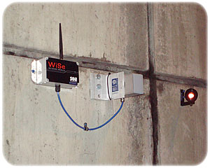 |
| Figure 5: A WiSe tiltmeter system was used on the U215 project to measure wall rotation. |
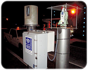 |
| Figure 6: The scanners were fitted with a lightweight carbon-fiber covers. The scanners’ on-site computer was fitted with a locked protective cover, wireless EVDO modems, and wired DSL as redundant communications paths. Automated motorized total stations were used for backup. |
Add new comment